Projects

Wildlife Crossing

Collaboration: Ashley Scott Kelly; Grant Connette; Hanna Helsingen; Paing Soe

This report is a collaboration between landscape designers, policy strategists, and species biologists from HKU, Smithsonian, WWF, FFI, and WCS. The importance of the study is that it takes abstract regional models from conservation biology developed over the past decade and applies them to site-specific conditions for the design of wildlife crossings where data is extremely limited. A set of principles was developed to reduce the abstraction and potential error in regional models of animal movement rate (proxied by electric circuit theory) and is potentially a breakthrough in multi-species modeling using these techniques, still critiqued as impractical only a year ago. The entire process is automated and outputs an optimized set of potential wildlife crossings as segments, rather than points, to allow flexibility in decision-making during road design and alignment due to costing and local landscape conditions.

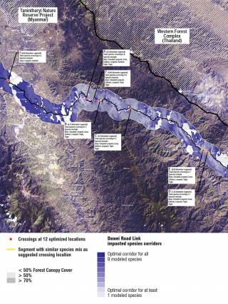
The Dawei Road Link, a planned 138-kilometer highway linking Bangkok to a 260-square-kilometer SEZ in Myanmar, bisects regional ecological corridors. This map shows the design team’s intervention sites used to convey landscape impacts, predict wildlife crossings, and test design strategies, 2016.
Advocating design as integral to upstream planning, especially without public EIAs and scarce environmental data, we developed tools, including semi-automated design scenarios and optimization algorithms for wildlife prediction, to fill in planning knowledge and data gaps, 2016.
Wildlife movement corridors were predicted based on likely reactions to forest cover, slope, ridges, streams, roads, and settlement. Nine critical species were tested using these inputs by an interdisciplinary team of experts from WWF, Smithsonian, FFI, WCS, and HKU, 2016.
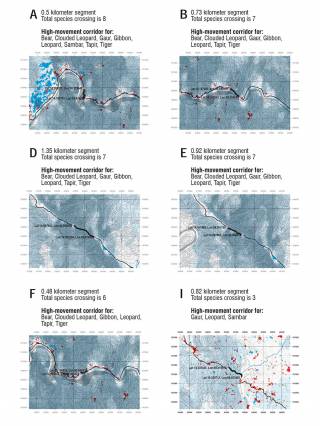
Multi-species corridor models, a current challenge in landscape ecology, were optimized by the design team based on eight principles, including: maximizing species movement rates, minimum number of crossing per species, distance between crossings, cold spot reduction, and corridor continuity, 2016.
Twelve wildlife crossing segments (not points), flexible enough to take into account local cost engineering and mitigation measures outlined in the accompanying Design Manual, were identified by the design team, 2016.