Critical Landscape Planning during the Belt and Road Initiative
(2018-2021)
Backcover text: This open access book traces the development of landscapes along the 414-kilometer China–Laos Railway, one of the first infrastructure projects implemented under China's Belt and Road Initiative (BRI) and which is due for completion at the end of 2021. Written from the perspective of landscape architecture and intended for planners and related professionals engaged in the development and conservation of these landscapes, this book provides history, planning pedagogy and interdisciplinary framing for working alongside the often-opaque planning, design and implementation processes of large-scale infrastructure. It complicates simplistic notions of development and urbanization frequently reproduced in the Laos–China frontier region. Many of the projects and sites investigated in this book are recent "firsts" in Laos: Laos's first wildlife sanctuary for trafficked endangered species, its first botanical garden and its first planting plan for a community forest. Most often the agents and accomplices of neoliberal development, the planning and design professions, including landscape architecture, have little dialogue with either the m...
Counter-assessment
Critical Landscape Planning for the Dawei Road Link, 1995-2019 (2018-19)
Environmental impact assessments bear the responsibility of assessing, negotiating, and ensuring accountability and deterrence of socioeconomic risks and environmental degradation. Most international standards call for cumulative impact analysis, which goes beyond the immediate physical impacts of construction and operation. However, for projects with long histories, here namely "projects" for the Dawei road link beginning in 1997, 2010, 2015, and 2019, what are most impactful are the ways these projects have incrementally, substantially, and sometimes violently rewritten these histories, albeit through the often technical languages of planning, engineering, ecology, and social science. Based on analysis of thousands of pages of company reports, over 150 unique sources, and high-resolution commercial satellite imagery, this project look inside the development process for clues of how to better assess the complex past and future impacts of infrastructure on our environment. Through constructing a novel two-decade history of the Dawei road corridor, I argue that more rigorous tools and frameworks are necessary to combat the amnesia of infrastructure d...

The Road to Dawei
Environmental governance and advocacy planning in southern Myanmar (2015-17)
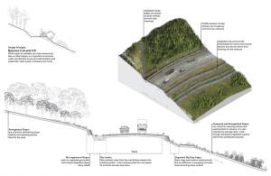
"The Road to Dawei" is an advocacy infrastructure planning project that addresses development impacts via environmental policy and physical implementation scenario-building. The simultaneously planned and under construction Dawei-Kanchanaburi Road Link connects Dawei, Myanmar to Bangkok across critical forest habitat and a culturally rich landscape just emerging from ethnic civil war into a new industrial and agricultural development paradigm. Weak environmental and development regulation requires multi-pronged approaches. Our planning project consists of three components: Promoting ecosystem services along the road; strategies for locating points of critical wildlife connectivity where data is scarce; and promoting sustainable road construction technologies. All three comprise a transcalar approach, from construction details to specific site strategies, landscape and transboundary planning. The landscape design team included policy specialists, ecologists, infrastructure planners, GIS specialists, and computer programmers to model scenarios and propose alternative construction practices to minimize environmental damage and fragmentation of critical...

Wildlife Crossing
Locating Species' Movement Corridors in Tanintharyi (2015-16)
This report is a collaboration between landscape designers, policy strategists, and species biologists from HKU, Smithsonian, WWF, FFI, and WCS. The importance of the study is that it takes abstract regional models from conservation biology developed over the past decade and applies them to site-specific conditions for the design of wildlife crossings where data is extremely limited. A set of principles was developed to reduce the abstraction and potential error in regional models of animal movement rate (proxied by electric circuit theory) and is potentially a breakthrough in multi-species modeling using these techniques, still critiqued as impractical only a year ago. The entire process is automated and outputs an optimized set of potential wildlife crossings as segments, rather than points, to allow flexibility in decision-making during road design and alignment due to costing and local landscape conditions.

Myanmar Design Manual
Building a Sustainable Road to Dawei (2015-16)
The manual combines species profiles and habitat characteristics with a catalog of sustainable road construction technologies and wildlife mitigation measures, and applies them to design scenarios at specific example sites along the Dawei road. Together, this manual and the Wildlife Crossing report a set of critical tools and approaches to planning, design, and maintenance of the Dawei road and similar large-scale infrastructure corridors. Both works target wide audiences and are written and graphically narrated to inform road builders, policy makers, and communities alike of best practices, risks, and the critical value of well-planned sustainable transport infrastructure.
The South America Project
Infrastructure and Protected Areas in the Peruvian Amazon (2011-14)
The Initiative for Integration of Regional Infrastructure, or IIRSA, is a continental multilateral mechanism financing connectivity through some of the most remote areas of Latin America. "Myths" of conservation, such as population and poverty driving deforestation or biodiversity as objective science, frequently couple global-regional models with the local specifics of place. Design here, through its physical and social agency, involves constructing partial perspectives that bridge global conservation (e.g., man-and-the-biosphere reserves) with paradoxes of the highly physical territories of conservation movements and remote agricultural frontiers. Entrenched in the methods and instruments of conservation and sustainability science, this project problematizes our stewardship of nature through tools of conservation across multiple disciplines and discourses.

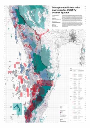
The Development and Conservation Awareness Map (DCAM) is piloted in Myanmar's Tanintharyi Region with civil society groups and international NGOs. The objective is to coordinate often contradictory knowledge of development projects, at any stage of planning and operation, impacting the region and to facilitate dialogue. This is paramount given the current climate of domestic and international investment in Tanintharyi, the complex state of dual-administration, the simultaneous presence of several international NGOs, the persistence of displaced persons and ethnic conflict, the drafting of new land use plans, forest laws, and impact requirements, and not least the region's crucial ecological value. As new plans for projects are discovered or as existing projects change course, they can be added to the map via simple drawing tools, uploading, and commentary. DCAM is intended to support a working knowledge of these landscapes. This effort to compile and present spatially explicit data is not alone in Myanmar, and in fact, several are in the pipeline by several organizations for pilot in Tanintharyi. DCAM is at most meant to fulfil a transitional but...
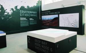
Counterpart Cities, PRD, China
Climate Change & Cooperative Action (2011-12)
Led by a curatorial team from the University of Hong Kong, the work suggests the collaboration of regional resources given impetus and/ or affected by climate change: Climate change as opportunity. Alongside wide-ranging research introducing the complexity of the region through the lens of major natural and man-made infrastructures, three design teams from Hong Kong and three from Shenzhen exhibit their visions for the regional cooperation of ports, freshwater delivery systems and cross-border ecologies.
Hong Kong Topography
Hong Kong Ground (2013-14)
This map presents initial trials of methods that can enable designers parametric and categorical control over complex surfaces, point clouds, and heavy data, from site-scale manipulations to the projective visualization of entire territories and land mosaics. The test site is a 27-square-kilometer area of Hong Kong Island that contains a representative sample of the territory's "features," including forested mountainsides, cascading artificial slopes and superimposed public grounds. The model is 100% interpolated from spot elevations, non-urban contours, and two-dimensional feature data.

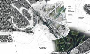
Gateway NRA Revitalization
Mapping the Ecotone (2007)
This project creates a highly visible, experiential public infrastructure that responds to the shifting ecosystem of Jamaica Bay and defines a new vision of the relationship between nature and people. Though within New York City, it is a stretch to call this an urban park in the context of Manhattan. Gateway must be made more accessible in terms of its idea.