Development and Conservation Awareness Map (DCAM). By Ashley Scott Kelly, 2022.
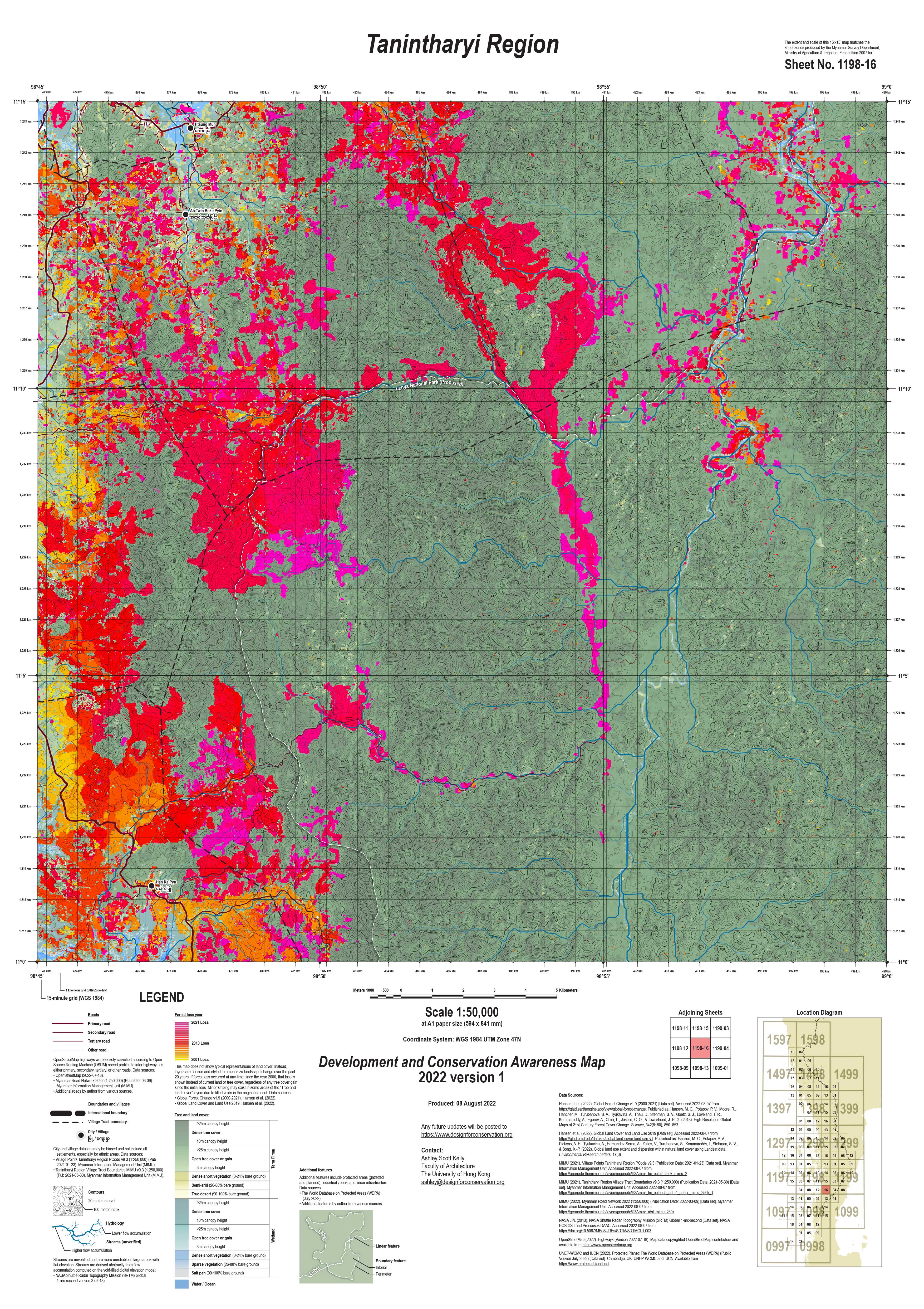
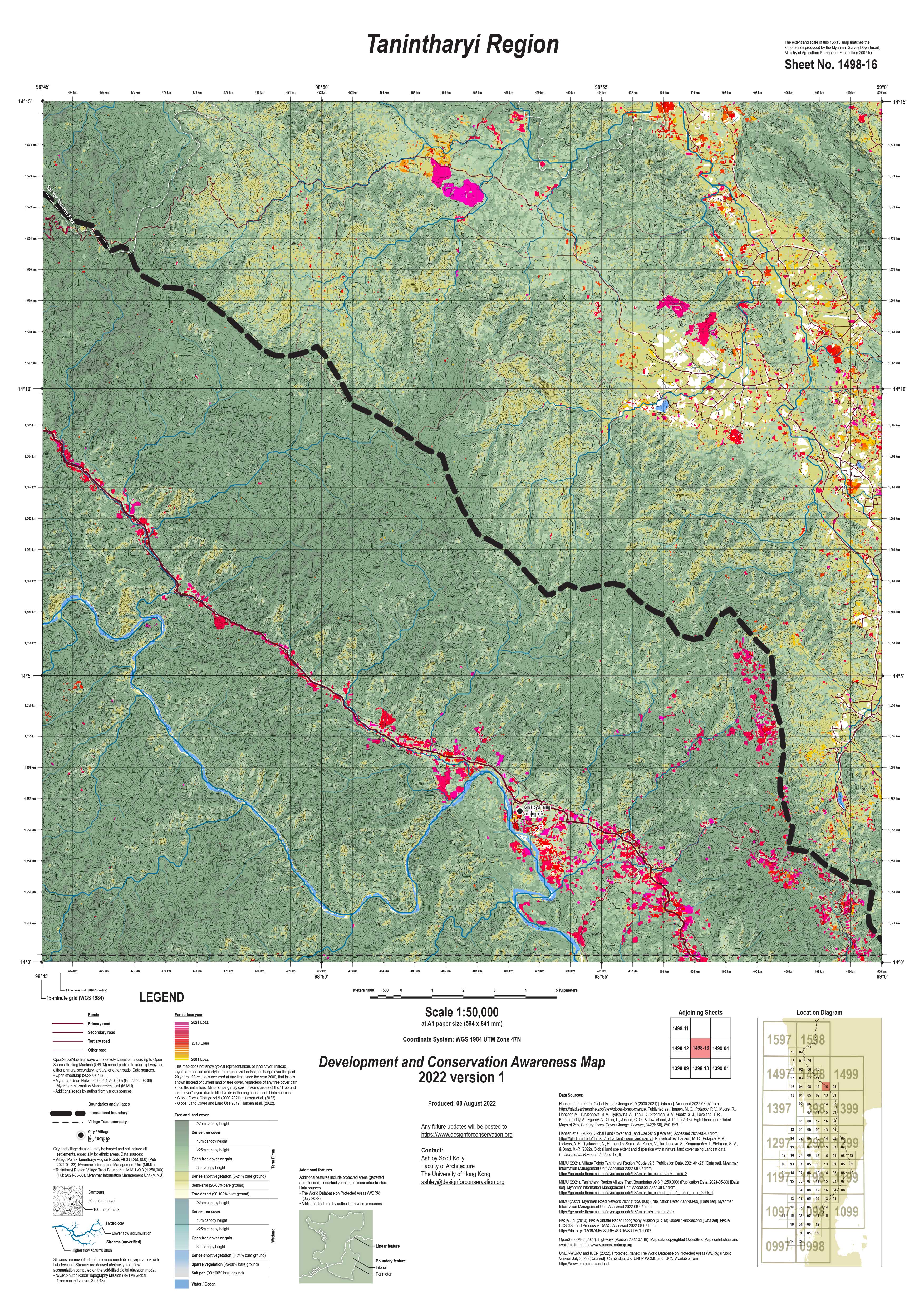
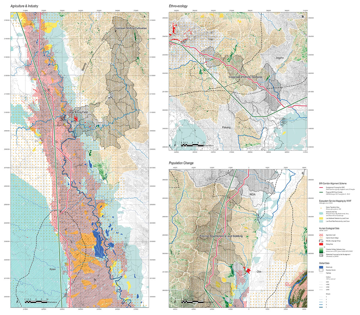
DCAM Map Sample, 2022.
DCAM Map Sample, 2022.
DCAM Map Sample, 2022.
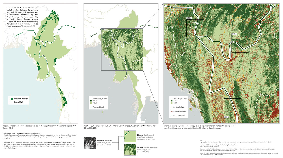
Constraints in criticality: A Review of WWF's position on the Belt and Road Initiative in Myanmar. By TANG Kenji, 2021.
Divergence between regional connectivity models and spatially explicit planning and design: Navigating generality, precision and expert opinion. By HUI Chun Sing, 2021.
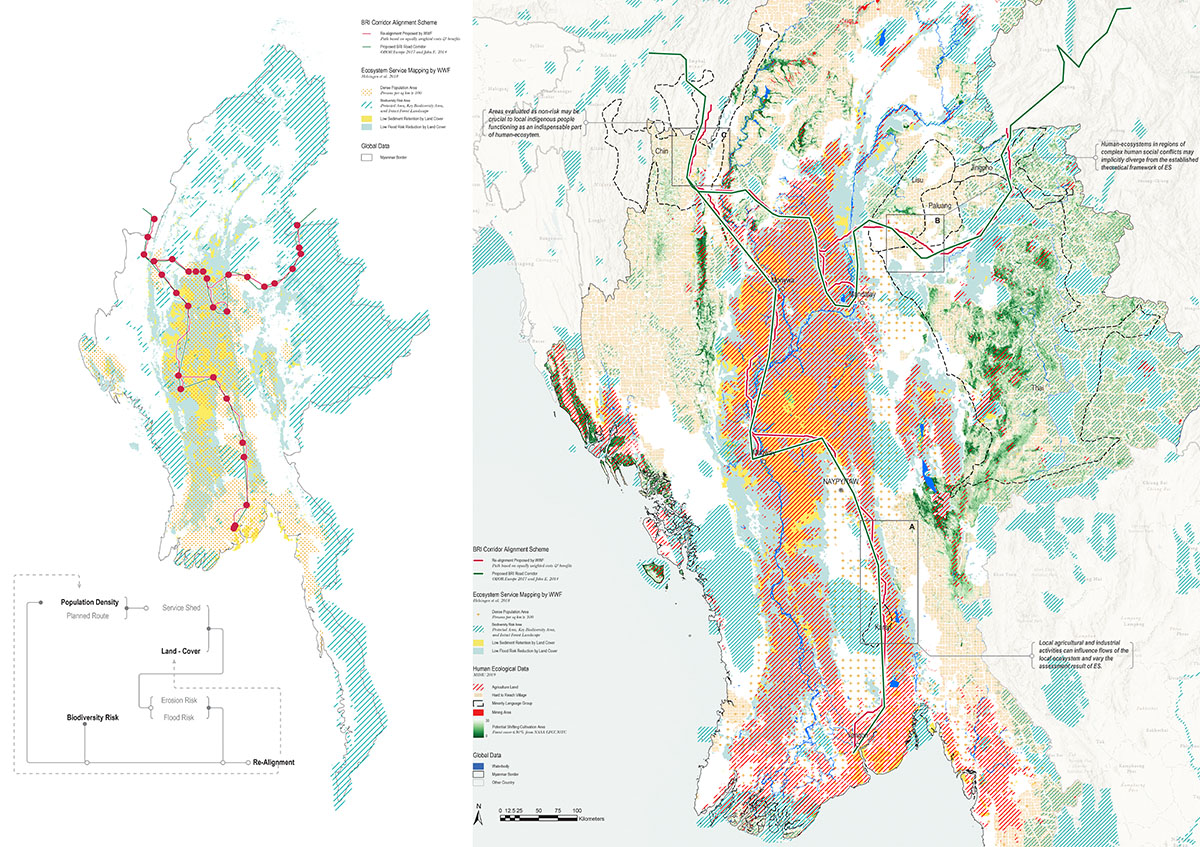
A Human-ecological reaction to WWF's use of ecosystem services prediction for infrastructure planning in Myanmar. By WEI Gongqi William, 2021.
A Human-ecological reaction to WWF's use of ecosystem services prediction for infrastructure planning in Myanmar. By WEI Gongqi William, 2021.
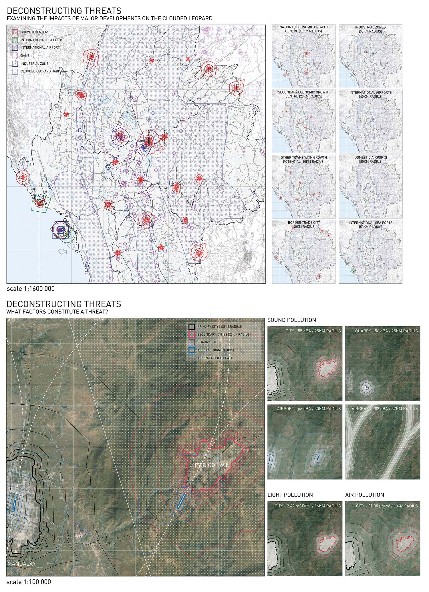
Deconstructing threats: What constitutes a threat and how does it relate specifically to the clouded leopard?. By Cho Quentin, 2021.
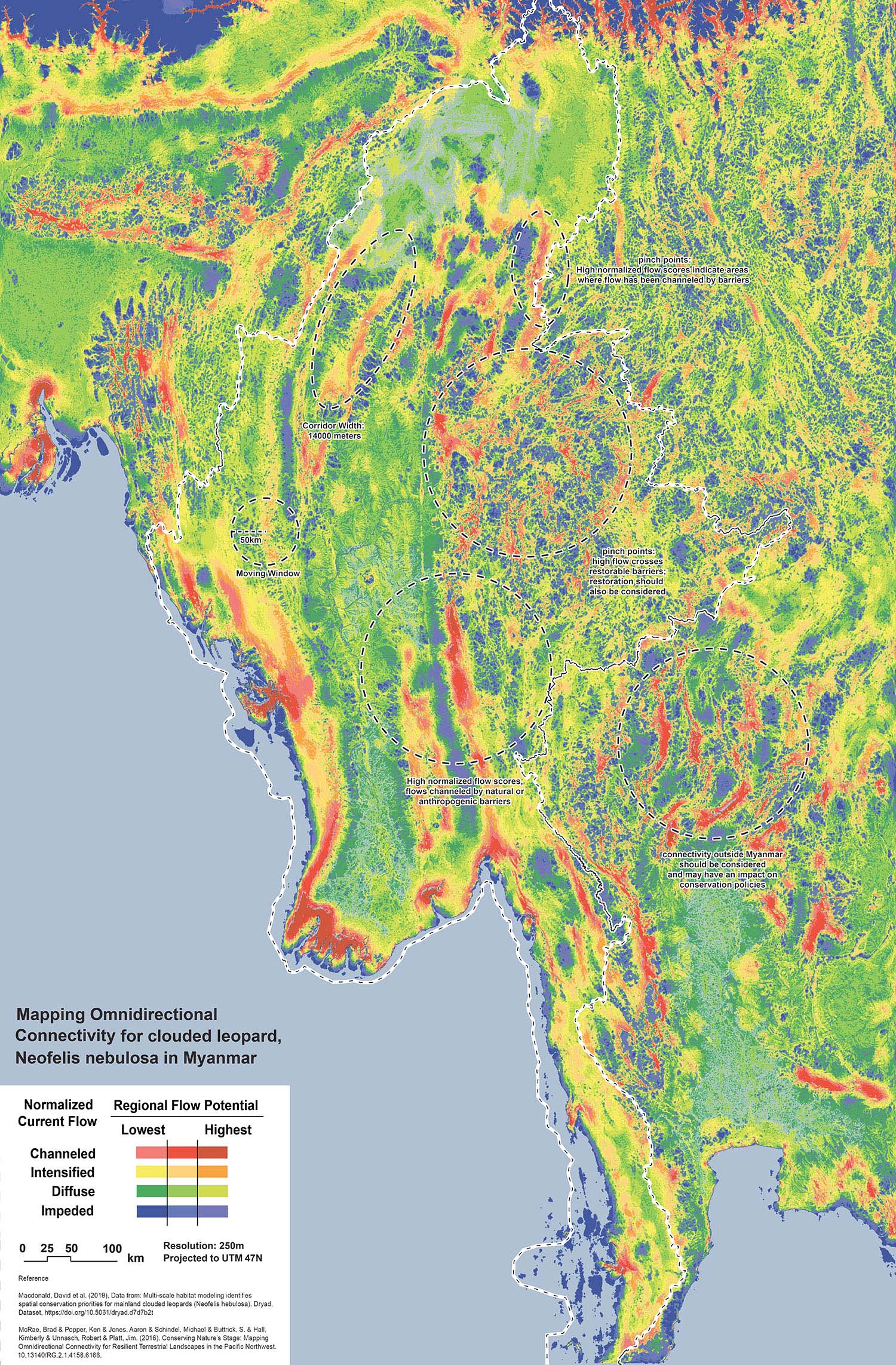
Mapping omnidirectional connectivity for clouded leopard, neofelis nebulosa in Myanmar. By Man Pak Him Jay, 2021.
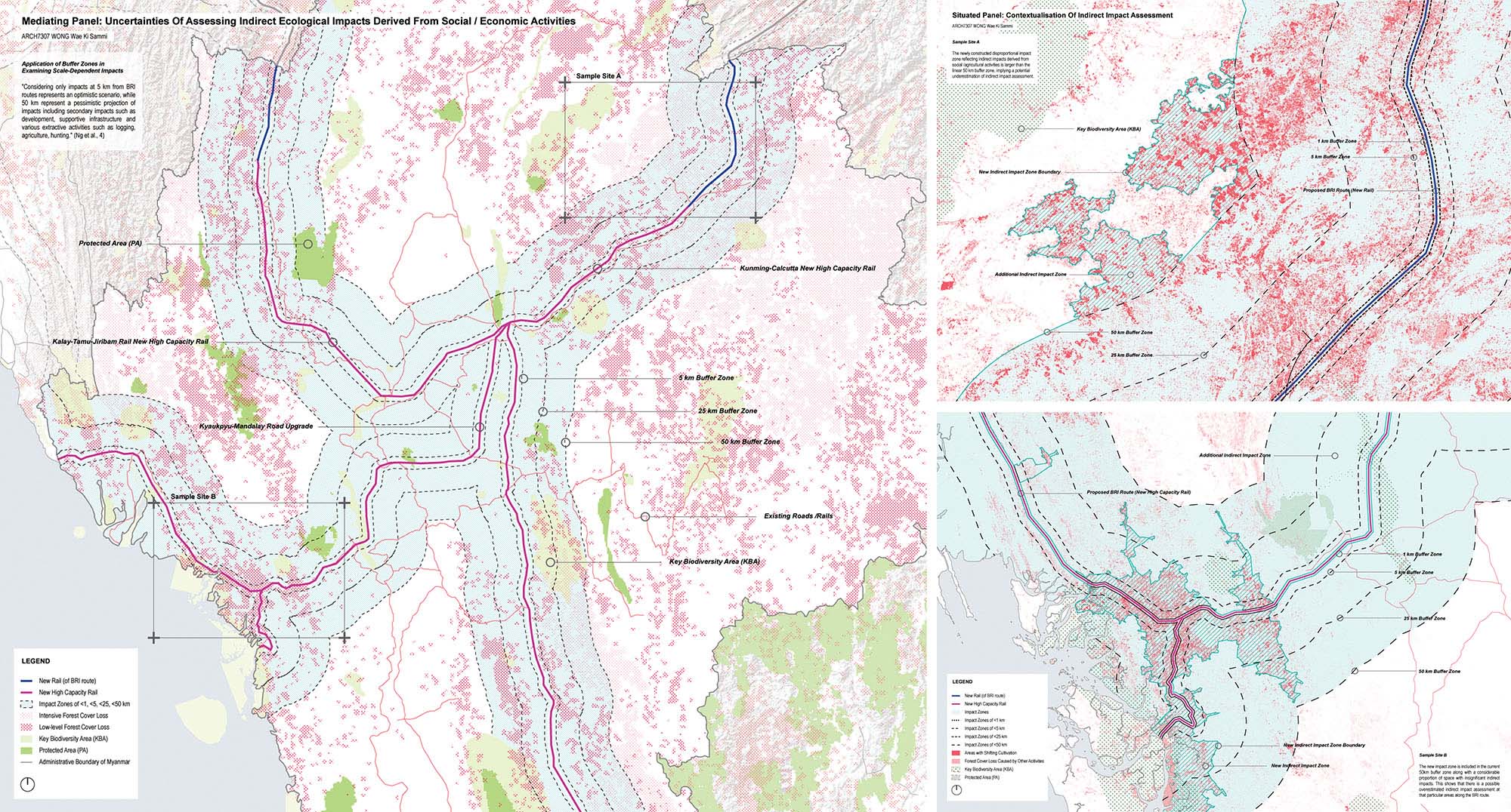
Complexities and uncertainties of Ecological Impact Assessment associated with BRI terrestrial infrastructure in Myanmar. By Wong Wae Ki Sammi, 2021.
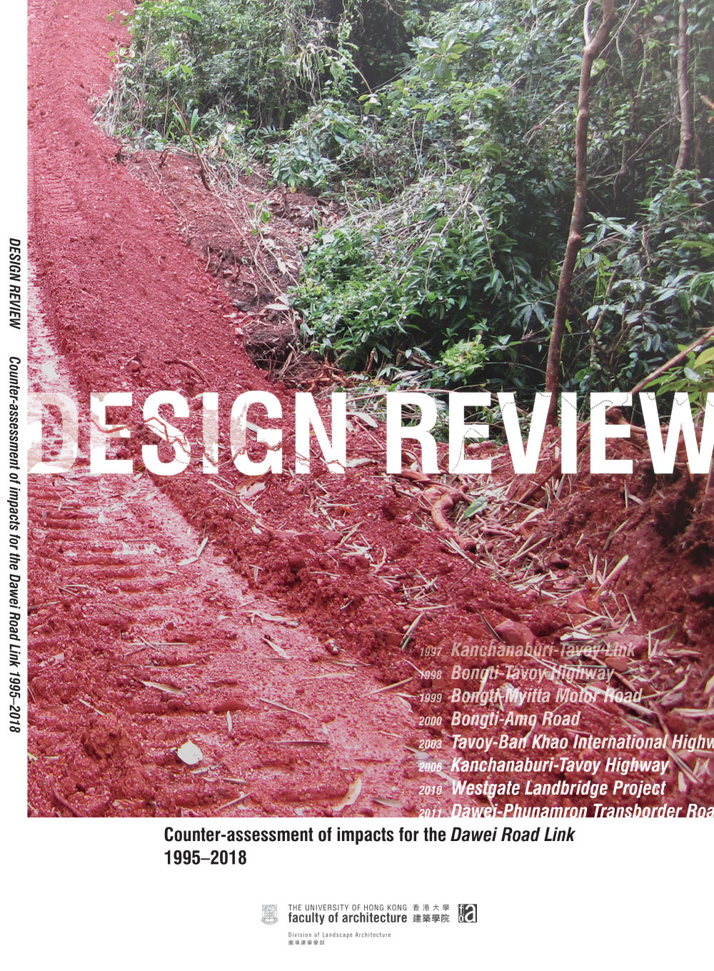
Design Review: Counter-assessment of impacts for the Dawei Road Link, 1995-2018 (Report), 2019.
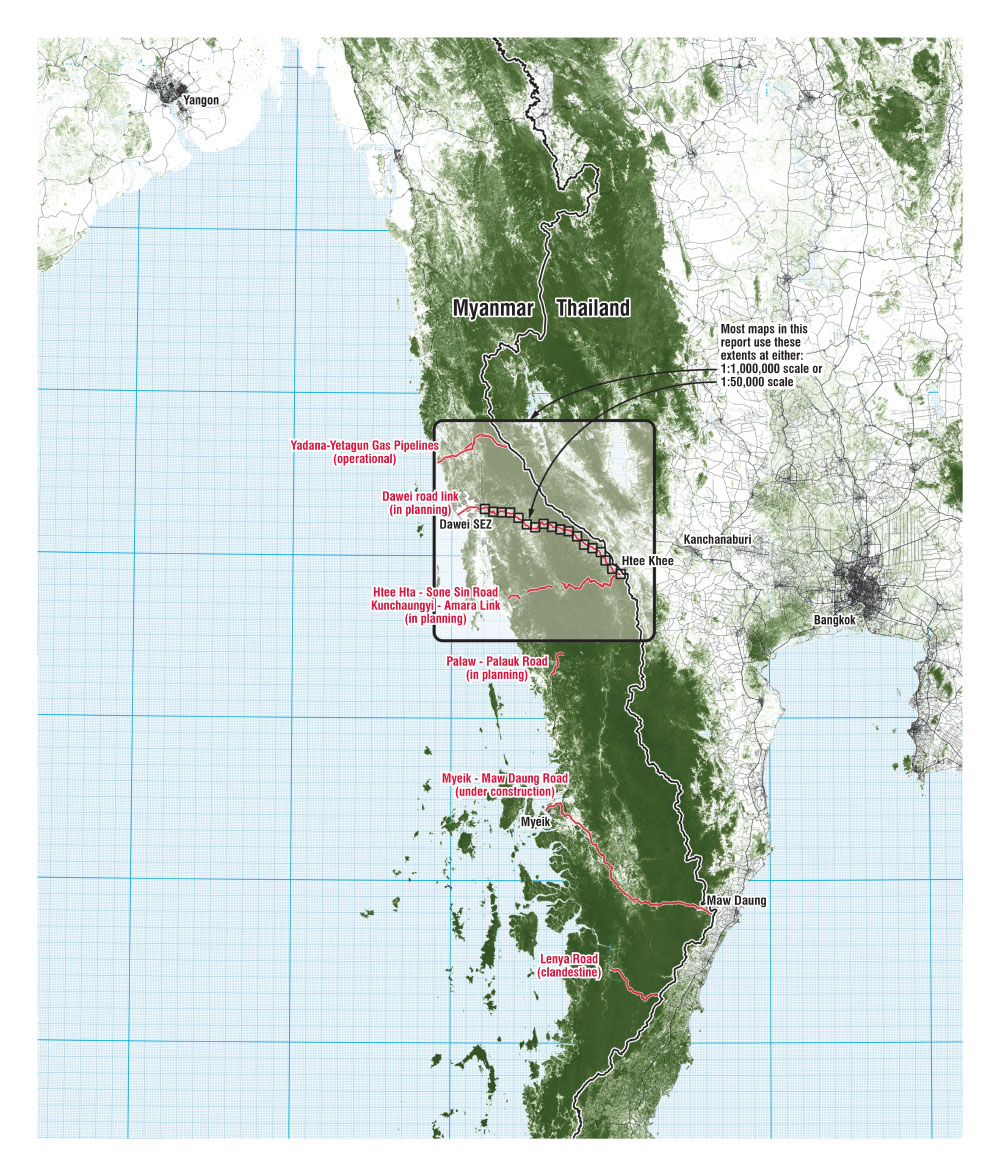
Planned linear infrastructure projects bisecting a globally important ecological corridor. By Ashley Scott Kelly, 2019.
Sample from Atlas of planning, construction and impact (1997-2018). By Ashley Scott Kelly, 2019.
Atlas of planning, construction and impact (1997-2018). By Ashley Scott Kelly, 2019.
ITD Dawei access road new construction and widening activity summary from 2010-2014. By Ashley Scott Kelly, 2019.
Timeline of EIA, construction and reconstruction. By Ashley Scott Kelly, 2019.
Construction progress of the Dawei road link access road and 4-lane highway (2010-2014). By Ashley Scott Kelly, 2019.
Expanding the scope of landscape assessment (2001-2018). By Ashley Scott Kelly, 2019.
Comprehensive timeline of the Dawei road link (1995-2018). By Ashley Scott Kelly, 2019.
Land cover classification methods comparison. By Ashley Scott Kelly, 2019.
Wildlife survey methods comparison. By Ashley Scott Kelly, 2019.
Discrepancies in station point technical documentation. By Ashley Scott Kelly, 2019.
Three planned alignments for the Dawei road link between Ah Moe and Kha Ta Ra Khee villages. By Ashley Scott Kelly, 2019.
Example map of discrepancies between planned roads, construction impact, and plot boundaries marked for compensation. By Ashley Scott Kelly, 2019.
Construction photos from ITD work progress reports (2011-2013). By Ashley Scott Kelly, 2019.
Available resolutions of satellite imagery near the Dawei road link. By Ashley Scott Kelly, 2019.
Availability and quality of satellite imagery along Dawei road link. By Ashley Scott Kelly, 2019.
Thailand and Dawei Special Economic Zone: Road Link to Kilometer Zero. By Siamrath Thai News, 2019.
Slide: Expanding the scope of landscape assessment. By Ashley Scott Kelly, 2019.
Slide: Expanding the scope of wildlife assessment. By Ashley Scott Kelly, 2019.
Slide: Background research for History of the Dawei road link. By Ashley Scott Kelly, 2019.
Slide: Alignments and ESIA consistency. By Ashley Scott Kelly, 2019.
Slide: Construction activity and satellite image availability. By Ashley Scott Kelly, 2019.
Slide: Construction activity and satellite image availability. By Ashley Scott Kelly, 2019.
Slide: What is a "project"? Does the Dawei road link "exist"?. By Ashley Scott Kelly, 2019.
Nature in peril: The risk to forests and wildlife from the Dawei-Htee Khee Road, 2019.
Nature in peril: The risk to forests and wildlife from the Dawei-Htee Khee Road, 2019.
Nature in peril: The risk to forests and wildlife from the Dawei-Htee Khee Road, 2019.
Studio final review. By TSANG Yik Ming Yammi, 2015.
Charity Cheung, final year BA(LS) student, presenting her proposal to integrate smallholders and large agroindustry through sustainable infrastructure and landscape planning. By TSANG Yik Ming Yammi, 2014.
Amanda Ton, final year BA(LS) student, presenting her proposal for alternative environmental management of the Ban Chaung coal mines. By TSANG Yik Ming Yammi, 2014.
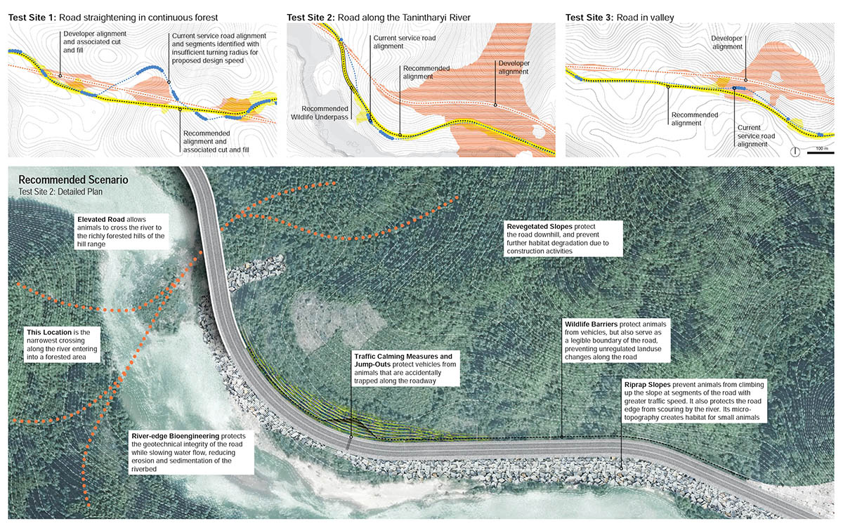
The Dawei Road Link, a planned 138-kilometer highway linking Bangkok to a 260-square-kilometer SEZ in Myanmar, bisects regional ecological corridors. This map shows the design team’s intervention sites used to convey landscape impacts, predict wildlife crossings, and test design strategies, 2016.
Bio-engineering technologies, principally for erosion control of tropical mountainous roads, are scoped for their additional potential to create micro-habitat, minimize degraded forest edges, and involve local communities in landscape maintenance, 2016.
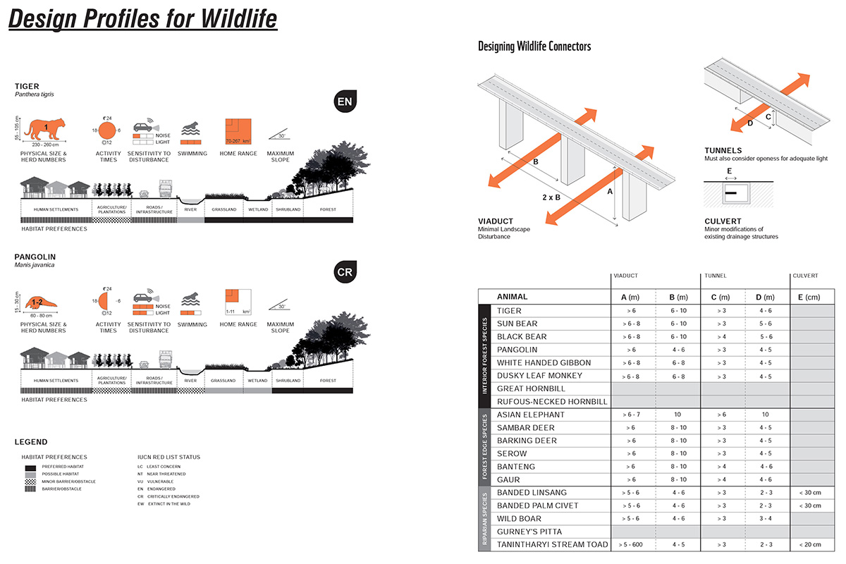
The Design Manual compiles detailed profiles of 20 threatened or endemic species typical of the project area, including critical behavioral aspects and dimensions necessary for infrastructure and mitigation design along the length of the Dawei Road Link, 2016.
Three prototypical sites are designed, with three scenarios each, to contrast the cost-centric engineering choices with low-impact landscape strategies. The recommended scenario shows the importance of design upstream in the planning process to minimize expensive late-stage mitigation, maintenance and monitoring, 2016.
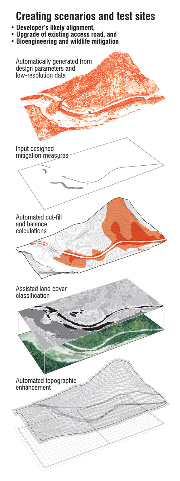
Test sites for design experimentation combined low-resolution global data with additional inputs including designed wildlife mitigation features, automated engineering cut and fill calculations, and land cover enhancement, 2016.
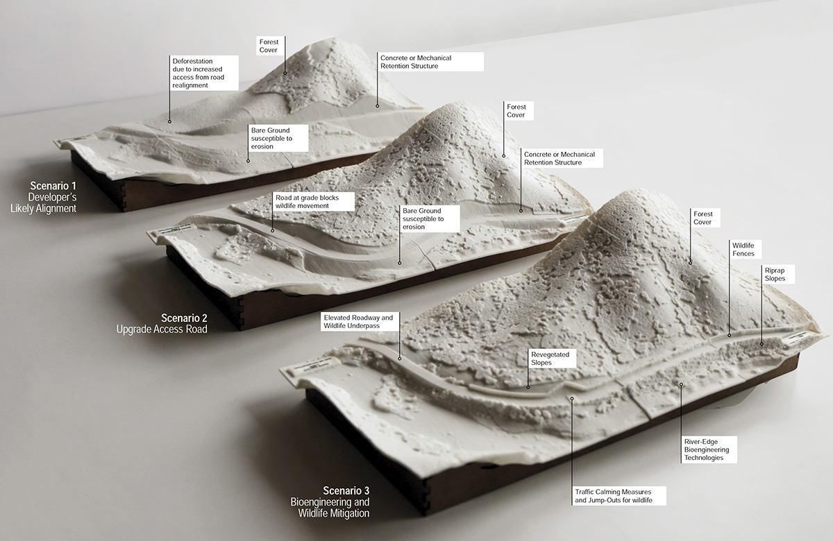
3D-printed design scenario models, 2016.
3D-printed landscape models, used in developer and government stakeholder meetings, contrast three design scenarios for a single site, including: 1) Developer’s likely alignment and construction; 2) Upgrade of access road; and 3) Bioengineering and wildlife mitigation. Printed with plant-derived plastics, 2016.
3D-printed design scenario models, 2016.
Diagram: AS Kelly; Photo: H Helsingen.
Diagram: AS Kelly.
Diagram: AS Kelly.
Diagram: AS Kelly; Model: A Dixon.
Dawei road near Bawapin Tin Mine. By Ashley Scott Kelly, 2015.
Students at the site of the SEZ's proposed reservoir, Kalonehtar village, Tanintharyi. By Dorothy Tang, 2015.
Students meeting with World Wide Fund for Nature (WWF) Mynamar in Yangon. By FEI Xiaoyan Mimi, 2015.
Tin mine extraction networks in Tanintharyi. By WONG Hiu Yan Monique, 2015.
Strategies for managing wildlife corridors in Tanintharyi. By PANG Tsz Yung Kity, 2015.
Community forestry in year 30: Self-reliance and sustainable economy for Tanintharyi Nature Reserve. By WONG Lok Yan Olive, 2015.
Excerpts from "Operation Manual: Speculating Dawei Special Economic Zone (DSEZ) Plan 2015". By YUEN Chun Yin Tony, 2015.
Dawei Special Economic Zone phase one investment and build-out scenario. By WONG Ting Fung Anson, 2015.
Buffer zone and landscape management in Tanintharyi National Park. By CHIU Ho Wan Issac, 2015.
Design for sustainable mining investment, Ban Chaung coal mine, year 2040. By TON Amanda, 2015.
Landscape strategy for equitable land use for large agro-industry and smallholders east of Dawei Special Economic Zone. By CHEUNG Oi Wai Charity, 2015.
Landscape planning strategy for smallholder agricultural cooperative. By AU YOUNG Chung Yan Sam, 2015.
Before and after section views of strategic planning for Myeik oil palm plantation. By AU YOUNG Chung Yan Sam, 2015.
Juxtaposition of smallholder agriculture and large-scale agro-industrial plantations. By AU YOUNG Chung Yan Sam, 2015.
Alternative energy schemes deployed under various planning principles for lower Tanintharyi River. By LIN Zhiqhi Chloe, 2015.
Integration scheme for negotiation of Karen village and agro-industrial development. By MCCULLOUGH Andrea, 2015.
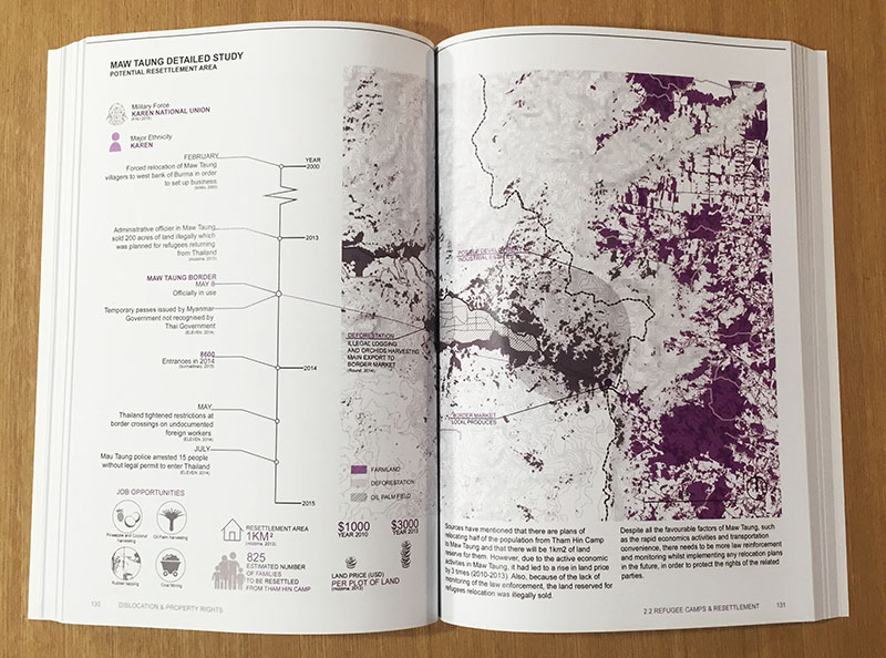
Timeline of land security struggles for villages in Tanintharyi Township. By WONG Wing Tung Eunice, 2015.
Landscape planning strategies for three villages impacted agroindustrial development. By WONG Wing Tung Eunice, 2015.
Catalog of forest management systems. By YUEN Ho Shun John, 2015.
Amanda Ton defends her landscape planning proposal for more sustainable approaches to coal mining in the Ban Chaung Valley, Myanmar during HKU Architecture's Public Review. By Scott Melbourne, 2014.
Andrea MCCULLOUGH presents her scheme for landscape-based negotiation and compensation within a large oil palm plantation. By LAM Wing Yan Rosemary, 2015.
Sam AU YOUNG Chung Yan defends her landscape planning proposal for equitable land rights for peoples displaced large-scale agroindustry during the Faculty of Architecture's Public Review, 2015.
Chloe LIN Zhiqi defends her landscape planning proposal for more sustainable energy generation for villages along the Tanintharyi River during the Faculty of Architecture's Public Review, 2015.
From Ethnic to Wildlife Conflict: Ecological corridors and refugee repatriation on the upper Tanintharyi River. By CHU Lok Yan Minnie, 2016.
From Ethnic to Wildlife Conflict: Ecological corridors and refugee repatriation on the upper Tanintharyi River. By CHU Lok Yan Minnie, 2016.
Max-capacity Landscapes: Village intensification, integration, and capacity-building for returning refugees on the Thai-Myanmar border. By HO Pik Lam Theodora, 2016.
Max-capacity Landscapes: Village intensification, integration, and capacity-building for returning refugees on the Thai-Myanmar border. By HO Pik Lam Theodora, 2016.
Max-capacity Landscapes: Village intensification, integration, and capacity-building for returning refugees on the Thai-Myanmar border. By HO Pik Lam Theodora, 2016.
Programming the Forest: Non-zoned approaches to customary rights in Tanintharyi Nature Reserve. By KHOO Ting Fung Natalie, 2016.
Programming the Forest: Non-zoned approaches to customary rights in Tanintharyi Nature Reserve. By KHOO Ting Fung Natalie, 2016.
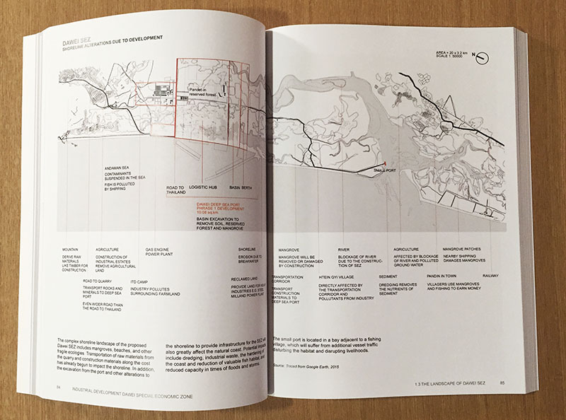
Programming the Forest: Non-zoned approaches to customary rights in Tanintharyi Nature Reserve. By KHOO Ting Fung Natalie, 2016.
Amplified Industrial Terrain: Micro-scale and anticipatory approaches to incremental planning of Dawei SEZ. By NG Lai Ching Daisy, 2016.
Amplified Industrial Terrain: Micro-scale and anticipatory approaches to incremental planning of Dawei SEZ. By NG Lai Ching Daisy, 2016.
Amplified Industrial Terrain: Micro-scale and anticipatory approaches to incremental planning of Dawei SEZ. By NG Lai Ching Daisy, 2016.
Extraction Untamed: Alternative environmental management strategies for Thai investment in Heinda tin mine. By TSOI King Yan Ingrid, 2016.
Extraction Untamed: Alternative environmental management strategies for Thai investment in Heinda tin mine. By TSOI King Yan Ingrid, 2016.
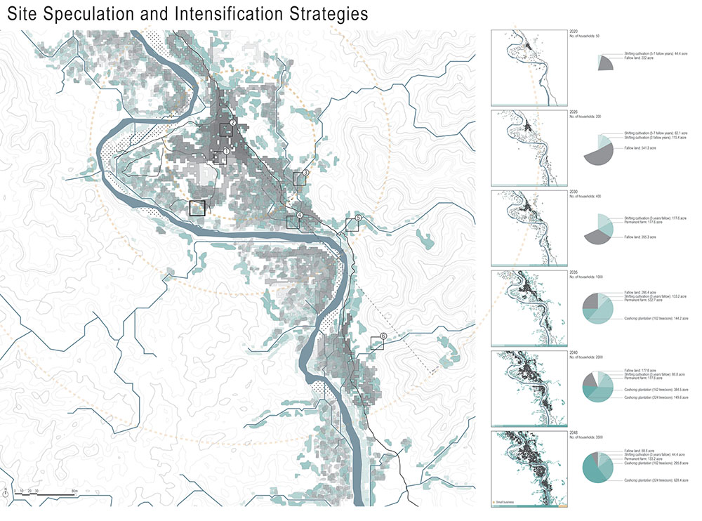
SEZ Occupied: Landscapes, compensation, and anticipating development through Village Priority Action Areas. By WANG Junwen David, 2016.
SEZ Occupied: Landscapes, compensation, and anticipating development through Village Priority Action Areas. By WANG Junwen David, 2016.
SEZ Occupied: Landscapes, compensation, and anticipating development through Village Priority Action Areas. By WANG Junwen David, 2016.
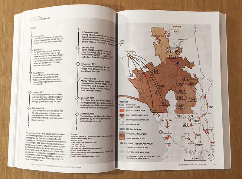
SEZ Occupied: Landscapes, compensation, and anticipating development through Village Priority Action Areas. By WANG Junwen David, 2016.
SEZ Occupied: Landscapes, compensation, and anticipating development through Village Priority Action Areas. By WANG Junwen David, 2016.
SEZ Occupied: Landscapes, compensation, and anticipating development through Village Priority Action Areas. By WANG Junwen David, 2016.
SEZ Occupied: Landscapes, compensation, and anticipating development through Village Priority Action Areas. By WANG Junwen David, 2016.
SEZ Occupied: Landscapes, compensation, and anticipating development through Village Priority Action Areas. By WANG Junwen David, 2016.
SEZ Occupied: Landscapes, compensation, and anticipating development through Village Priority Action Areas. By WANG Junwen David, 2016.
SEZ Occupied: Landscapes, compensation, and anticipating development through Village Priority Action Areas. By WANG Junwen David, 2016.
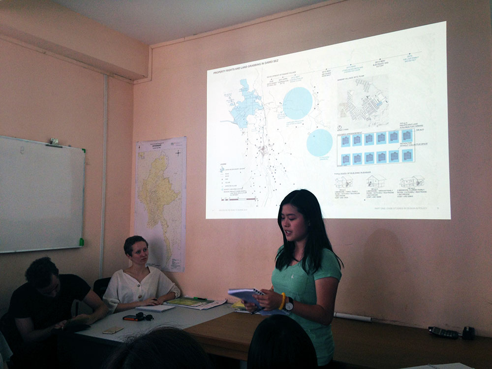
Engineered Land Rights: Compensation, displacement and alternative impact scopes for the Dawei Road Link. By ZHANG Tongtong Sherly, 2016.
Engineered Land Rights: Compensation, displacement and alternative impact scopes for the Dawei Road Link. By ZHANG Tongtong Sherly, 2016.
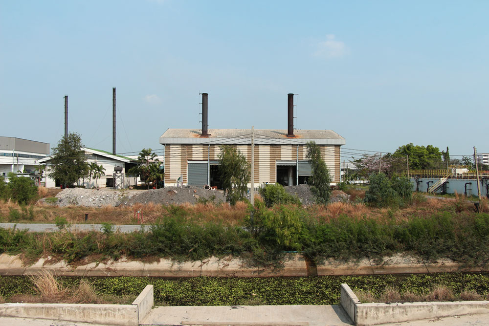
Case study site visit to petrochemical estate, Map Ta Phut, Thailand. By Ashley Scott Kelly, 2016.
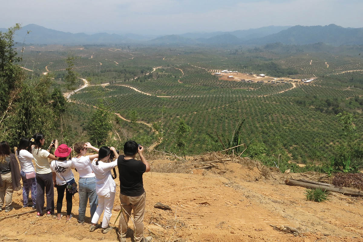
Oil palm plantations on unsuitable slopes in southern Myanmar. By Ashley Scott Kelly, 2016.
HKU students observing the Myanmar Stark Prestige Plantation (MSPP) east of Myeik city, Tanintharyi, Myanmar. By Ashley Scott Kelly, 2016.
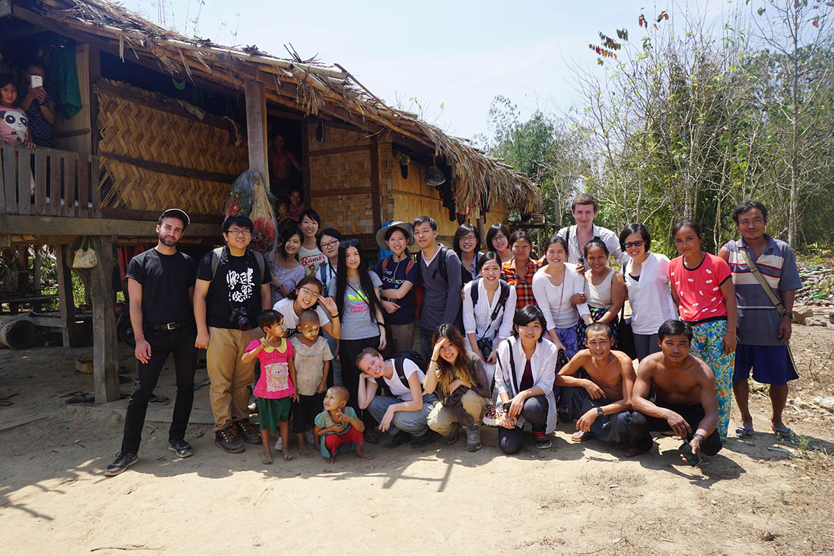
Studio class with Karen villagers in Tanintharyi, Myanmar. By LAM Wing Yan Rosemary, 2015.
MSPP oil palm plantation in Tanintharyi District, 2016.
Oil palm and rubber plantations in Myeik District. By Dorothy Tang, 2016.
HKU students at WWF office in Yangon. By LAM Wing Yan, 2016.
By LAM Wing Yan, 2016.
By LAM Wing Yan, 2016.
By Ashley Scott Kelly, 2016.
By Ashley Scott Kelly, 2016.
By Ashley Scott Kelly, 2016.
By Ashley Scott Kelly, 2016.
By Ashley Scott Kelly, 2016.
By Ashley Scott Kelly, 2016.
By Ashley Scott Kelly, 2016.
By Ashley Scott Kelly, 2016.
By FONG Hei Yi, 2016.
By Ashley Scott Kelly, 2016.
By LI Hiu Lam, 2016.
By Ashley Scott Kelly, 2016.
By LAM Wing Yan, 2016.
By LAM Wing Yan, 2016.
By Ashley Scott Kelly, 2016.
By Ashley Scott Kelly, 2016.
By Ashley Scott Kelly, 2016.
By Ashley Scott Kelly, 2016.
By Ashley Scott Kelly, 2016.
By Ashley Scott Kelly, 2016.
By Ashley Scott Kelly, 2016.
By LIN Zhiqi, 2016.
By Dorothy Tang, 2016.
By AU YOUNG Chung Yan, 2016.
By AU YOUNG Chung Yan, 2016.
By Dorothy Tang, 2016.
By LUI Ka Yi, 2016.
By Dorothy Tang, 2016.
By Dorothy Tang, 2016.
By Dorothy Tang, 2016.
By Ashley Scott Kelly, 2016.
By Ashley Scott Kelly, 2016.
By LUI Ka Yi, 2016.
By CHAN Yeuk Nam, 2016.
By Ashley Scott Kelly, 2016.
By Ashley Scott Kelly, 2016.
By AU YOUNG Chung Yan, 2016.
By Dorothy Tang, 2016.
By Ashley Scott Kelly, 2016.
By Ashley Scott Kelly, 2016.
By Ashley Scott Kelly, 2016.
By Ashley Scott Kelly, 2016.
By LAM Wing Yan, 2016.
By Ashley Scott Kelly, 2016.
By YUEN Ho Shun, 2016.
By LAM Wing Yan, 2016.
By LAM Wing Yan, 2016.
By Ashley Scott Kelly, 2016.
By LAM Wing Yan, 2016.
Site visit along Dawei Road Link at Elephant Cry Hill, Tanintharyi, Myanmar. By Ashley Scott Kelly, 2017.
Students meeting with Michaunglaung village to discuss TNRP Corporate Social Responsibility program. By Maxime Decaudin, 2016.
Map Ta Phut Industrial Estate on Thailand's Eastern Seaboard. By Ashley Scott Kelly, 2017.
Interfaith ceremony for Fish Conservation Zone, Kamoethway. By Ashley Scott Kelly, 2017.
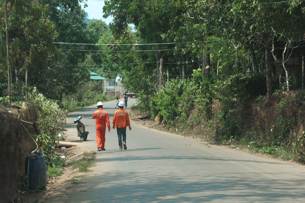
Dawei SEZ main road. By Ashley Scott Kelly, 2017.
Students participated in village wildlife conservation ceremony, Tanintharyi, Myanmar. By LAU Tik Sze Daisy, 2017.
Map Ta Phut Industrial Estate on Thailand's Eastern Seaboard. By Ashley Scott Kelly, 2017.
LNG Terminal, Map Ta Phut Industrial Estate, Thailand. By Ashley Scott Kelly, 2017.
LNG Terminal, Map Ta Phut Industrial Estate, Thailand. By Ashley Scott Kelly, 2017.
LNG Terminal, Map Ta Phut Industrial Estate, Thailand. By Ashley Scott Kelly, 2017.
LNG Terminal, Map Ta Phut Industrial Estate, Thailand. By Ashley Scott Kelly, 2017.
Drainage infrastructure. Map Ta Phut Industrial Estate, Thailand. By Ashley Scott Kelly, 2017.
Students studying drainage infrastructure. Map Ta Phut Industrial Estate, Thailand. By Ashley Scott Kelly, 2017.
Drainage infrastructure. Map Ta Phut Industrial Estate, Thailand. By Ashley Scott Kelly, 2017.
Map Ta Phut Industrial Estate on Thailand's Eastern Seaboard. By Ashley Scott Kelly, 2017.
Map Ta Phut Industrial Estate on Thailand's Eastern Seaboard. By Ashley Scott Kelly, 2017.
Drainage infrastructure. Map Ta Phut Industrial Estate, Thailand. By Ashley Scott Kelly, 2017.
Infrastructure corridor. Map Ta Phut Industrial Estate, Thailand. By Ashley Scott Kelly, 2017.
Infrastructure corridor. Map Ta Phut Industrial Estate, Thailand. By Ashley Scott Kelly, 2017.
Drainage infrastructure. Map Ta Phut Industrial Estate, Thailand. By Ashley Scott Kelly, 2017.
Infrastructure corridor. Map Ta Phut Industrial Estate, Thailand. By Ashley Scott Kelly, 2017.
Map Ta Phut Industrial Estate on Thailand's Eastern Seaboard. By Ashley Scott Kelly, 2017.
Map Ta Phut Industrial Estate on Thailand's Eastern Seaboard. By Ashley Scott Kelly, 2017.
Map Ta Phut Industrial Estate on Thailand's Eastern Seaboard. By Ashley Scott Kelly, 2017.
Drainage infrastructure. Map Ta Phut Industrial Estate, Thailand. By Ashley Scott Kelly, 2017.
LNG Terminal, Map Ta Phut Industrial Estate, Thailand. By LAU Tik Sze Daisy, 2017.
LNG Terminal, Map Ta Phut Industrial Estate, Thailand. By LAU Tik Sze Daisy, 2017.
Map Ta Phut Industrial Estate on Thailand's Eastern Seaboard. By Ashley Scott Kelly, 2017.
Map Ta Phut Industrial Estate on Thailand's Eastern Seaboard. By Ashley Scott Kelly, 2017.
Map Ta Phut Industrial Estate on Thailand's Eastern Seaboard. By Ashley Scott Kelly, 2017.
Map Ta Phut Industrial Estate on Thailand's Eastern Seaboard. By Ashley Scott Kelly, 2017.
Map Ta Phut Industrial Estate on Thailand's Eastern Seaboard. By Ashley Scott Kelly, 2017.
Drainage infrastructure. Laem Chabang Industrial Estate, Thailand. By Ashley Scott Kelly, 2017.
Drainage infrastructure. Laem Chabang Industrial Estate, Thailand. By Ashley Scott Kelly, 2017.
Laem Chabang Industrial Estate on Thailand's Eastern Seaboard. By Ashley Scott Kelly, 2017.
Laem Chabang Industrial Estate on Thailand's Eastern Seaboard. By Ashley Scott Kelly, 2017.
Drainage infrastructure. Laem Chabang Industrial Estate, Thailand. By Ashley Scott Kelly, 2017.
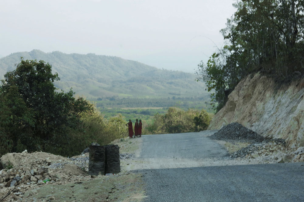
Dawei-Phunamron Road Link access road. By Ashley Scott Kelly, 2017.
Dawei-Phunamron Road Link access road. By Ashley Scott Kelly, 2017.
Dawei-Phunamron Road Link access road. By Ashley Scott Kelly, 2017.
Dawei-Phunamron Road Link access road. By Ashley Scott Kelly, 2017.
Dawei-Phunamron Road Link access road. By Ashley Scott Kelly, 2017.
Htee Khee Border Crossing. By Ashley Scott Kelly, 2017.
Forest fire near Myitta. By Ashley Scott Kelly, 2017.
Dawei-Phunamron Road Link access road. By Ashley Scott Kelly, 2017.
ITD Base Camp along access road. By Ashley Scott Kelly, 2017.
Dawei-Phunamron Road Link access road. By Ashley Scott Kelly, 2017.
ITD Base Camp along access road. By Ashley Scott Kelly, 2017.
Dawei-Phunamron Road Link access road. By Ashley Scott Kelly, 2017.
Dawei-Phunamron Road Link access road. By Ashley Scott Kelly, 2017.
Dawei-Phunamron Road Link access road. By Ashley Scott Kelly, 2017.
Dawei-Phunamron Road Link access road. By Ashley Scott Kelly, 2017.
Dawei-Phunamron Road Link access road. By Ashley Scott Kelly, 2017.
Recently cleared agricultural land along access road. By Ashley Scott Kelly, 2017.
Students observing small-scale gold mining in the Tanintharyi River. By Ashley Scott Kelly, 2017.
Small-scale gold mining in the Tanintharyi River. By Ashley Scott Kelly, 2017.
Mining along the Dawei-Myitta road. By Ashley Scott Kelly, 2017.
WWII monument at Myitta. By Ashley Scott Kelly, 2017.
Western half of Dawei-Phunamrom Road Link access road. By Ashley Scott Kelly, 2017.
Western half of Dawei-Phunamrom Road Link access road. By Ashley Scott Kelly, 2017.
Interfaith ceremony for Fish Conservation Zone, Kamoethway. By Ashley Scott Kelly, 2017.
Students celebrating 3rd anniversary of Kamoethway Fish Conservation Zone. By Ashley Scott Kelly, 2017.
Students celebrating 3rd anniversary of Kamoethway Fish Conservation Zone. By Ashley Scott Kelly, 2017.
Interfaith shrine to halt the construction of the Dawei-Phunamron Road Link. By Ashley Scott Kelly, 2017.
Students meeting with leader of Rays of Kamoethway Indigenous People and Nature (RKIPN). By Ashley Scott Kelly, 2017.
Village in Kamoethway River basin. By Ashley Scott Kelly, 2017.
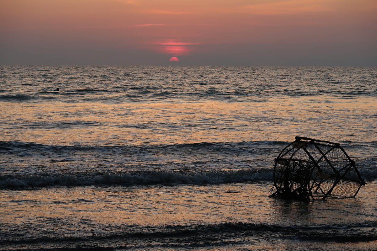
Maungmagan Beach. By Ashley Scott Kelly, 2017.
Maungmagan Beach. By Ashley Scott Kelly, 2017.
National Highway 8 north of Dawei. By HO Pik Lam Theodora, 2017.
National Highway 8 north of Dawei. By KHOO Ting Fung Natalie, 2017.
Dawei-Yangon railroad (25 hour journey). By OH Sungho David, 2017.
National Highway 8 north of Dawei. By ZHANG Tongtong Sherly, 2017.
Students meeting with Michaunglaung village to discuss TNRP Corporate Social Responsibility program. By Maxime Decaudin, 2017.
Students meeting with Michaunglaung village to discuss TNRP Corporate Social Responsibility program. By Maxime Decaudin, 2017.
Near Michaunglaung village. By Ashley Scott Kelly, 2017.
Near Michaunglaung village. By Ashley Scott Kelly, 2017.
Near Michaunglaung village. By Ashley Scott Kelly, 2017.
Michaunglaung village, 2 hours north of Dawei. By Ashley Scott Kelly, 2017.
Students meeting with Michaunglaung village to discuss TNRP Corporate Social Responsibility program. By Ashley Scott Kelly, 2017.
Students meeting with Michaunglaung village to discuss TNRP Corporate Social Responsibility program. By LAU Tik Sze Daisy, 2017.
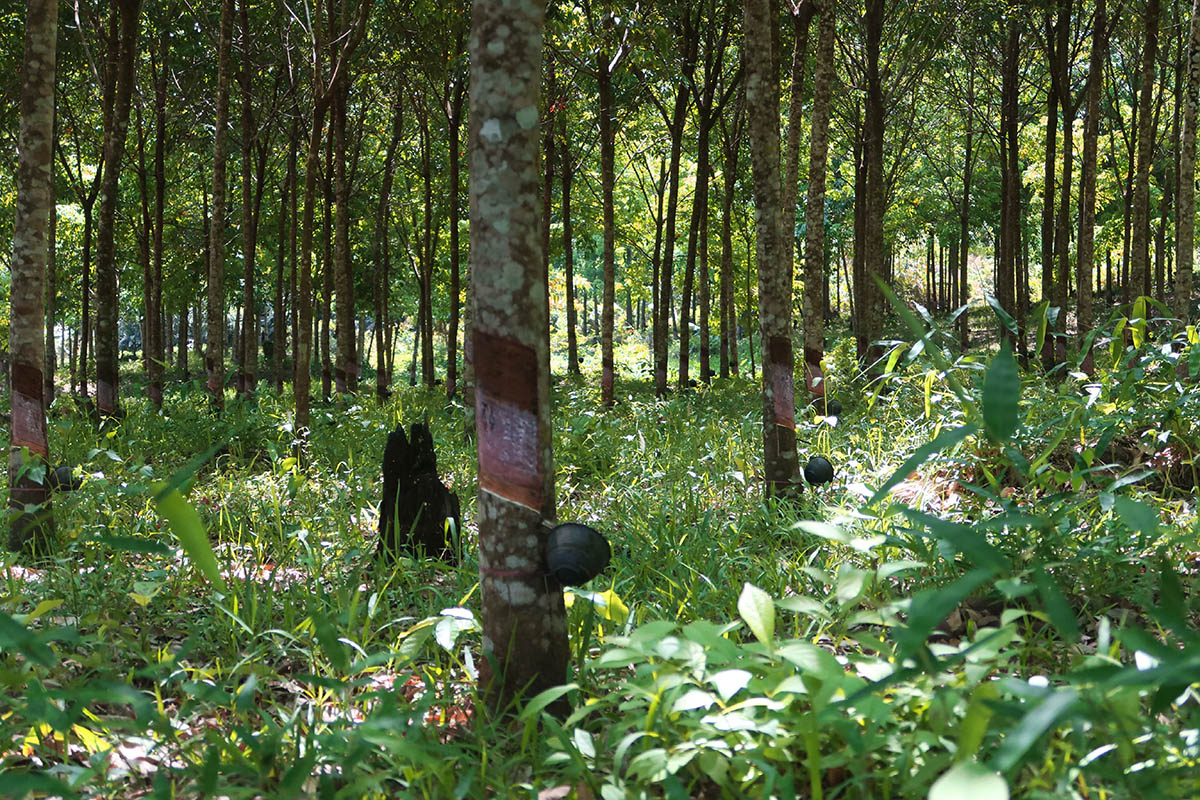
Rubber tapping near Total Yadana-Yetagun gas pipelines. By HO Pik Lam Theodora, 2017.
Rubber tapping near Total Yadana-Yetagun gas pipelines. By HO Pik Lam Theodora, 2017.
Yadana-Yetagun gas pipeline corridor. By Ashley Scott Kelly, 2017.
Yadana-Yetagun gas pipeline corridor. By Ashley Scott Kelly, 2017.
Yadana-Yetagun gas pipeline corridor. By Ashley Scott Kelly, 2017.
Rubber sheets drying within the Yadana-Yetagun gas pipeline corridor. By WU Jiaheng Andrea, 2017.
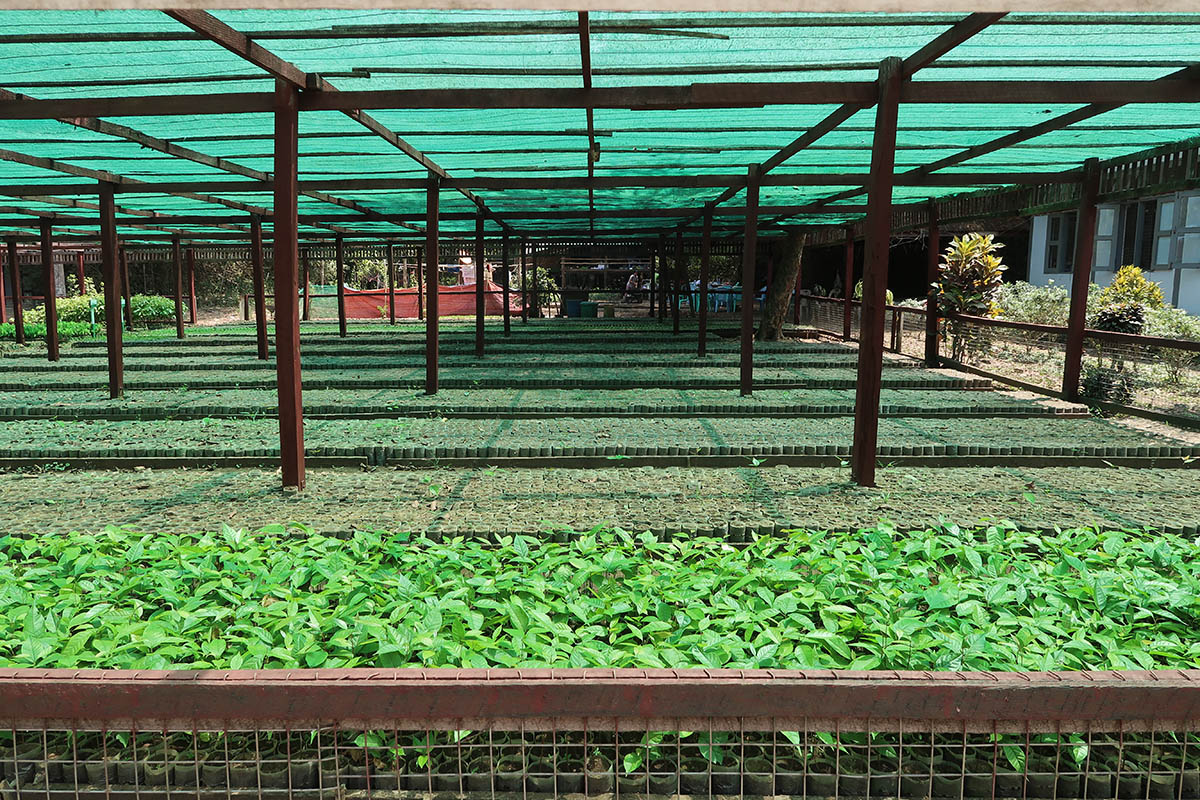
Tanintharyi Nature Reserve Project nursery. By Ashley Scott Kelly, 2017.
Oil palm plantation on Dawei SEZ. By HO Pik Lam Theodora, 2017.
Dawei SEZ overlooking cement yard. By Ashley Scott Kelly, 2017.
Dawei SEZ drainage works. By Ashley Scott Kelly, 2017.
Management Committee buidling, Dawei SEZ. By Ashley Scott Kelly, 2017.
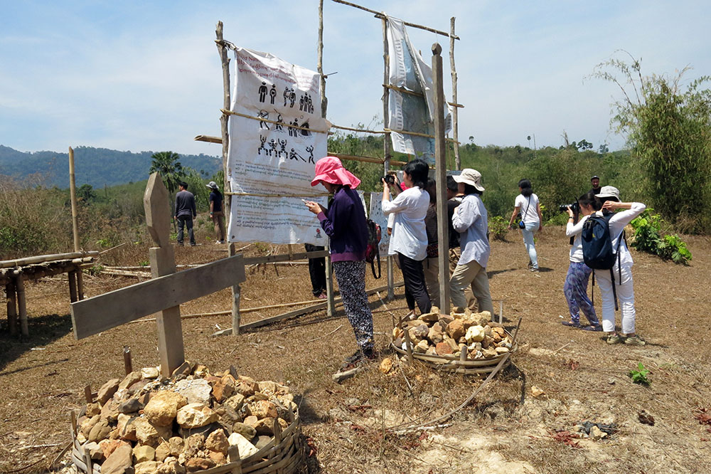
Bawar resettlement site for Dawei SEZ impacted villages (no occupancy, built 2012). By Ashley Scott Kelly, 2017.
Bawar resettlement site for Dawei SEZ impacted villages (no occupancy, built 2012). By Ashley Scott Kelly, 2017.
Bawar resettlement site for Dawei SEZ impacted villages (no occupancy, built 2012). By Ashley Scott Kelly, 2017.
Bawar resettlement site for Dawei SEZ impacted villages (no occupancy, built 2012). By Ashley Scott Kelly, 2017.
Bawar resettlement site for Dawei SEZ impacted villages (no occupancy, built 2012). By Ashley Scott Kelly, 2017.
ITD building at Bawar resettlement site. By Ashley Scott Kelly, 2017.
Kilometer zero, Dawei SEZ. By Ashley Scott Kelly, 2017.
Kilometer zero, Dawei SEZ. By Ashley Scott Kelly, 2017.
Small port at Dawei SEZ. By Ashley Scott Kelly, 2017.
Small port at Dawei SEZ. By Ashley Scott Kelly, 2017.
Small port at Dawei SEZ. By Ashley Scott Kelly, 2017.
Small port at Dawei SEZ. By Ashley Scott Kelly, 2017.
Small port at Dawei SEZ. By Ashley Scott Kelly, 2017.
Mangroves at Dawei SEZ small port. By Ashley Scott Kelly, 2017.
Mangroves at Dawei SEZ small port. By Ashley Scott Kelly, 2017.
Dawei city. By Ashley Scott Kelly, 2017.
Dawei city. By Ashley Scott Kelly, 2017.
Aerial view of agricultural fields south (downstream) of Dawei SEZ. By HO Pik Lam Theodora, 2017.
Aerial view of Dawei SEZ Phase I area. By HO Pik Lam Theodora, 2017.
Aerial view of Dawei SEZ Phase I area. By Ashley Scott Kelly, 2017.
Aerial view of Kanbauk mine (upper right) and Total gas pipeline facilities (bottom center). By Ashley Scott Kelly, 2017.
Students visited the Drug Elimination Museum in Yangon to learn about the Tatmadaw's development of ethnic regions. By Ashley Scott Kelly, 2017.
Students visited the Drug Elimination Museum in Yangon to learn about the Tatmadaw's development of ethnic regions. By Ashley Scott Kelly, 2017.
Students meeting with Wildlife Conservation Society (WCS) Myanmar in Yangon. By Maxime Decaudin, 2017.
Students meeting with World Wide Fund for Nature (WWF) Myanmar in Yangon. By Maxime Decaudin, 2017.
Students meeting with World Wide Fund for Nature (WWF) Myanmar in Yangon. By Maxime Decaudin, 2017.
Government officials touring land use change and road development in Tanintharyi, 2015.
Site-specific vignettes show the impacts of road construction and dependency of road sustainability on ecosystem services. These include erosion control, landslide prevention, habitat fragmentation, disturbance, and loss, flood regulation, air quality, and secondary impacts of land use change and development, 2015.
Long-isolated due to six decades of civil war, this region now faces pressure from domestic and transnational development, weak land rights, and large-scale resource exploitation. This map, published online by the design team, compiles contradictory planning knowledge and facilitates dialogue, 2015.
Three reports highlight 1) ecosystem services and environmental regulation, 2) wildlife crossings modelling, and 3) design guidelines for sustainable road construction with wildlife mitigation. A collaboration with WWF, these were generated rapidly over 10 months due to imminent threats of construction, 2016.
This Roadmap, presented here to Myanmar's national Highways Department, outlines sustainable planning, design, construction, and maintenance stages of road development. Institutionalizing wildlife and ecosystem services is critical given Myanmar's evolving environmental and developmental regulation and rich natural and cultural landscape, 2015.
Final review for Design on the Road to Burma 2017.
Minnie CHU Lok Yan presenting project From Ethnic to Wildlife Conflict: Ecological corridors and refugee repatriation on the upper Tanintharyi River.
Critics debate the possible futures of the Dawei Special Economic Zone.
Daisy LAU Tik Sze presents her project on alternative economies for community forestry and the defunding of Tanintharyi Nature Reserve Project.
Natalie KHOO Ting Fung defends her project Programming the Forest: Non-zoned approaches to customary rights in Tanintharyi Nature Reserve.
Advocating design as integral to upstream planning, especially without public EIAs and scarce environmental data, we developed tools, including semi-automated design scenarios and optimization algorithms for wildlife prediction, to fill in planning knowledge and data gaps, 2016.
Wildlife movement corridors were predicted based on likely reactions to forest cover, slope, ridges, streams, roads, and settlement. Nine critical species were tested using these inputs by an interdisciplinary team of experts from WWF, Smithsonian, FFI, WCS, and HKU, 2016.
Multi-species corridor models, a current challenge in landscape ecology, were optimized by the design team based on eight principles, including: maximizing species movement rates, minimum number of crossing per species, distance between crossings, cold spot reduction, and corridor continuity, 2016.
Twelve wildlife crossing segments (not points), flexible enough to take into account local cost engineering and mitigation measures outlined in the accompanying Design Manual, were identified by the design team, 2016.
Dawei-Myitta road near Bawapin tin mine. By Ashley Scott Kelly, 2015.
Tenasserim (Tanintharyi) River. By WONG Ting Fung, 2015.
Navanakorn Industrial Park (Thailand) housing estate. By CHAN Ka Ying, 2015.
Navanakorn Industrial Park (Thailand) canal. By Ashley Scott Kelly, 2015.
Navanakorn Industrial Park (Thailand). By WONG Lok Yan, 2015.
Bangpain Industrial Park (Thailand). By FEI Xiaoyan, 2015.
Bangpain Industrial Park (Thailand) flood wall. By TON Amanda, 2015.
Dawei-Kanchanaburi Road Link. By WONG Lok Yan, 2015.
Dawei-Kanchanaburi Road Link. By YUEN Ka Hei, 2015.
Hellfire Pass, Kanchanaburi. By LUI Kayi, 2015.
Hellfire Pass, Kanchanaburi. By Dorothy Tang, 2015.
Meeting with The Border Consortium (TBC). By TSANG Yik Ming, 2015.
Meeting with The Border Consortium (TBC). By TSANG Yik Ming, 2015.
Former colonial retreat at Maungmagan Beach. By Ashley Scott Kelly, 2015.
Dawei SEZ shoreline. By CHIU Ho Wan, 2015.
Cement Yard at Dawei SEZ site. By CHIU Ho Wan, 2015.
Main artery, Dawei SEZ site. By Ashley Scott Kelly, 2015.
Main artery, Dawei SEZ site. By Dorothy Tang, 2015.
Bawah Resettlement Site. By CHIU Ho Wan, 2015.
Dawei palm alley. By Ashley Scott Kelly, 2015.
National Highway 8 (just north of SEZ). By TON Amanda, 2015.
Total Yadana gas pipeline CSR area. By Dorothy Tang, 2015.
Total Yadana gas pipeline CSR area (Kaleinaung Pagoda overlook). By Ashley Scott Kelly, 2015.
Total Corporate Social Responsibility (CSR) Gas plant near Michaunglaung. By Dorothy Tang, 2015.
Tanintharyi Nature Reserve Project (TNRP) Michaunglaung Education Centre. By TSANG Yik Ming, 2015.
Tanintharyi Nature Reserve Project (TNRP) Michaunglaung Nursery. By Chiu Ho Wan, 2015.