Teaching

Landscape Representation

Instructor: Ashley Scott Kelly

At The University of Hong Kong

Course abstract:

Landscape Representation offers a landscape-centric approach to digital analysis and representation. While sharing histories and methods with architecture and planning, landscape representation, given its engagement with natural processes and ecologies, requires greater control over complex forms and materials. This course established students' foundational knowledge in computer science and geographic information systems (GIS) through reviewing innovations, vocabularies, and impacts of disruptive technologies on design and project delivery since the 1960s. While these histories help form a critical understanding of software as a medium of design, this course also questioned the inherent problems of landscape as a digital and narrative medium. Students manipulated geospatial data from remotely sensed and open-source datasets to build a generalist's understanding of geospatial digital media for the range of scales that landscape architects confront and in which they collaborate. Automation and iterative, procedural workflows were stressed as part of an efficient design process and problem-solving toolset for landscape research and design, from regional to site-scale works.

    For their term projects, students applied GIS and parametric modeling tools to explore landscape and biodiversity modeling techniques for measuring connectivity, fragmentation, species richness, and environmental impact with a focus on describing issues of data quality, scientific bias, reductive methodologies, and disciplinary blindspots in landscape ecology.

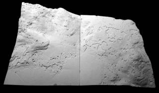
    1:2500 model. By CHU Lok Yan Minnie, 2016.
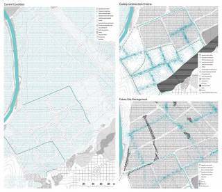
    1:2500 model. By CHU Lok Yan Minnie, 2016.
    1:2500 model. By CHU Lok Yan Minnie, 2016.
    1:2500 model. By CHU Lok Yan Minnie, 2016.
    1:2500 model. By CHU Lok Yan Minnie, 2016.
    1:2500 model. By CHU Lok Yan Minnie, 2016.
    1:500 model. By CHU Lok Yan Minnie, 2016.
    1:500 model. By CHU Lok Yan Minnie, 2016.
    1:2500 plan showing vegetation cover distribution at 2000 and 2012. By WANG Junwen David, 2016.
    1:2500 plan showing vegetation cover distribution at 2000 and 2012. By WANG Junwen David, 2016.
    Section series showing vegetation cover distribution at 2000 and 2012 around Aberdeen Country Park and South Island Line tunnel construction area. By WANG Junwen David, 2016.
    Section series showing vegetation cover distribution at 2000 and 2012 around Aberdeen Country Park and South Island Line tunnel construction area. By WANG Junwen David, 2016.
    1:2500 model detail. By WANG Junwen David, 2016.
    1:2500 model detail. By WANG Junwen David, 2016.
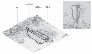
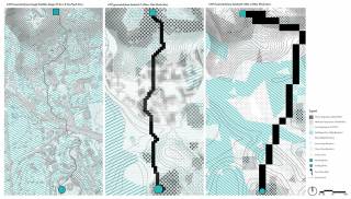
    Least cost path (LCP) explorations of habitat connectivity across ecological scales in Kowloon. By CHEUNG Man Huen Jodie, CHEUNG Tsz Yui Edelweiss, and LEUNG Yik Chun, 2020.
    Least cost path (LCP) explorations of habitat connectivity across ecological scales in Kowloon. By CHEUNG Man Huen Jodie, CHEUNG Tsz Yui Edelweiss, and LEUNG Yik Chun, 2020.
    Singular surface model of habitat connectivity across ecological scales in Kowloon. By CHUNG Won Seok John, LEE Yin Ching Athena, and WONG Hon Ting Bryan, 2020.
    Singular surface model of habitat connectivity across ecological scales in Kowloon. By CHUNG Won Seok John, LEE Yin Ching Athena, and WONG Hon Ting Bryan, 2020.
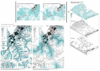
    Comparison of landslide susceptibility models in Lantau. By HO Dai Rong Heather, LIU Jiani Vicki, and ZHANG Jenifer, 2020.
    Comparison of landslide susceptibility models in Lantau. By HO Dai Rong Heather, LIU Jiani Vicki, and ZHANG Jenifer, 2020.
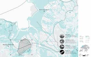
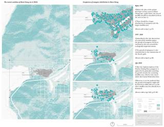
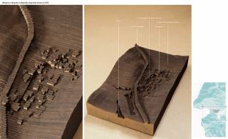
    Hypothetical species distributions across three time periods in Fung Lok Wai, Hong Kong. By LEUNG Chun Fai Anson, 2019.
    Hypothetical species distributions across three time periods in Fung Lok Wai, Hong Kong. By LEUNG Chun Fai Anson, 2019.
    Hypothetical species distributions across three time periods in Fung Lok Wai, Hong Kong. By LEUNG Chun Fai Anson, 2019.
    Hypothetical species distributions across three time periods in Fung Lok Wai, Hong Kong. By LEUNG Chun Fai Anson, 2019.
    1:2500 model detail. By ZHANG Tongtong Sherly, 2016.
    1:2500 model detail. By ZHANG Tongtong Sherly, 2016.
    1:2500 model detail. By ZHANG Tongtong Sherly, 2016.
    1:2500 model detail. By ZHANG Tongtong Sherly, 2016.
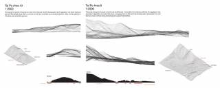
    Site sections for Tai Po development sites, Area 9 and Area 10. By ZHANG Tongtong Sherly, 2016.
    Site sections for Tai Po development sites, Area 9 and Area 10. By ZHANG Tongtong Sherly, 2016.
    1:2500 model detail. By ZHANG Tongtong Sherly, 2016.
    1:2500 model detail. By ZHANG Tongtong Sherly, 2016.
    1:2500 model. By ZHANG Tongtong Sherly, 2016.
    1:2500 model. By ZHANG Tongtong Sherly, 2016.
    1:2500 model. By ZHANG Tongtong Sherly, 2016.
    1:2500 model. By ZHANG Tongtong Sherly, 2016.
    1:2500 model detail. By ZHANG Tongtong Sherly, 2016.
    1:2500 model detail. By ZHANG Tongtong Sherly, 2016.
    1:2500 model. By ZHANG Tongtong Sherly, 2016.
    1:2500 model. By ZHANG Tongtong Sherly, 2016.
    1:2500 model. By ZHANG Tongtong Sherly, 2016.
    1:2500 model. By ZHANG Tongtong Sherly, 2016.
    1:2500 model. By ZHANG Tongtong Sherly, 2016.
    1:2500 model. By ZHANG Tongtong Sherly, 2016.
    1:500 model. By ZHANG Tongtong Sherly, 2016.
    1:500 model. By ZHANG Tongtong Sherly, 2016.
    1:500 model. By ZHANG Tongtong Sherly, 2016.
    1:500 model. By ZHANG Tongtong Sherly, 2016.
    Site drawings for Tai Po Area 9 and Area 10. By ZHANG Tongtong Sherly, 2016.
    Site drawings for Tai Po Area 9 and Area 10. By ZHANG Tongtong Sherly, 2016.
    1:500 model. By NG Lai Ching Daisy, 2016.
    1:500 model. By NG Lai Ching Daisy, 2016.
    Shui Hau Penisula mudflat, Lantau Island. By LIN Zhiqi Chloe, 2014.
    Shui Hau Penisula mudflat, Lantau Island. By LIN Zhiqi Chloe, 2014.
    Zoning and environment of So Lo Pun. By NG Lai Ching Daisy, 2015.
    Zoning and environment of So Lo Pun. By NG Lai Ching Daisy, 2015.
    Zoning and environment of So Lo Pun. By NG Lai Ching Daisy, 2015.
    Zoning and environment of So Lo Pun. By NG Lai Ching Daisy, 2015.
    Agricultural land cover change of Lai Chi Wo. By KHOO Ting Fung Natalie, 2015.
    Agricultural land cover change of Lai Chi Wo. By KHOO Ting Fung Natalie, 2015.
    Tai O salt pans and mangroves. By WANG Junwen David, 2015.
    Tai O salt pans and mangroves. By WANG Junwen David, 2015.
    By CHUNG Kwan Yu Lillian, 2016.
    By CHUNG Kwan Yu Lillian, 2016.
    By MAK Sui Hin Jack, 2016.
    By MAK Sui Hin Jack, 2016.
    By ZOU Wenyao May, 2016.
    By ZOU Wenyao May, 2016.
    By WONG Oi Ling Ellena, 2016.
    By WONG Oi Ling Ellena, 2016.
    By WONG Oi Ling Ellena, 2016.
    By WONG Oi Ling Ellena, 2016.
    By LI Haolin Tred, 2017.
    By LI Haolin Tred, 2017.
    By WONG Yuen Shan Candice, 2017.
    By WONG Yuen Shan Candice, 2017.
    By WONG Yuen Shan Candice, 2017.
    By WONG Yuen Shan Candice, 2017.
    By CHAN Sze Wah Naomi, 2017.
    By CHAN Sze Wah Naomi, 2017.
    By CHAN Sze Wah Naomi, 2017.
    By CHAN Sze Wah Naomi, 2017.
    By CHAN Sze Wah Naomi, 2017.
    By CHAN Sze Wah Naomi, 2017.
    Comparison between landslide susceptibility mapping methods on Lantau Island. By Wong Nok Lam Joyce; Li Huitong Lydia; Li Ziyuan Lena, 2021.
    Comparison between landslide susceptibility mapping methods on Lantau Island. By Wong Nok Lam Joyce; Li Huitong Lydia; Li Ziyuan Lena, 2021.
    Least cost path (LCP) comparisons of habitat connectivity across different spatial resolutions in Kowloon. By Lai Man Ki Maisy; Chau Ngai Tung Bobo; Li William, 2021.
    Least cost path (LCP) comparisons of habitat connectivity across different spatial resolutions in Kowloon. By Lai Man Ki Maisy; Chau Ngai Tung Bobo; Li William, 2021.
    Least cost path (LCP) comparisons of habitat connectivity across different spatial resolutions in Kowloon. By Lai Man Ki Maisy; Chau Ngai Tung Bobo; Li William, 2021.
    Least cost path (LCP) comparisons of habitat connectivity across different spatial resolutions in Kowloon. By Lai Man Ki Maisy; Chau Ngai Tung Bobo; Li William, 2021.